The Geograph® Britain and Ireland project aims to collect geographically
representative photographs and information for every square kilometre of Great Britain and
Ireland, and you can be part of it.
Since 2005, 13,876 contributors have submitted 7,725,269 images covering 282,563 grid squares, or 85.1% of the total squares
Photograph of the day
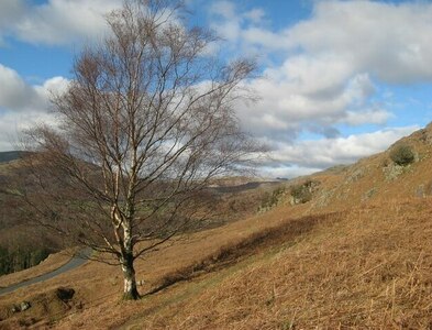
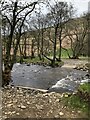
Solitary birch by Jonathan Wilkins for square SD2090, taken Monday, 26 February, 2024
Coverage Map
Click the map to start browsing photos
What is Geographing?
- It's a game - how many grid squares will you contribute?
- It's a geography project for the people
- It's a national photography project
- It's a good excuse to get out more!
- It's a free and open online community project for all
Registration is free so come and join us and see how many grid squares you submit!
Recent Photos
63,523 photographed squares with fewer than 4 photos, add yours now!
Featured Collection

Geo-trip by David Lally, 41 images. Updated 8 days ago.
Staying on the Deepdale backpackers site in late March I saw a poster describing... (more)
Geograph® Britain and Ireland is a project by Geograph Project Limited,
a Charity Registered in England and Wales, no 1145621. Company no 7473967.
The registered office is Dept 1706, 43 Owston Road, Carcroft, Doncaster, South Yorkshire. DN6 8DA.
The registered office is Dept 1706, 43 Owston Road, Carcroft, Doncaster, South Yorkshire. DN6 8DA.
This site is archived for preservation by the UK Web Archive, Internet Archive and WikiMedia Commons projects.